


Waters have receded, ending the flood threat after Alaska's capital city faced record floodwaters Wednesday stemming from a basin dammed by the Mendenhall Glacier, which released an "outburst flood" that threatened parts of Juneau.
"I think we were all very grateful to see the Hesko barriers work," Katie Koester, the Juneau city manager, said in an interview with CBS News on Wednesday evening. "We can all breathe a sigh of relief. For the most part, we had very minimal flooding and avoided a really catastrophic event."
Water levels in the Mendenhall River, which flows through Juneau, reached unprecedented heights in the early morning hours and peaked at around 7:15 a.m. local time before beginning to fall, the National Weather Service said. At its peak, the river's flood stage rose to 16.65 feet, topping the previous record of 15.99 feet set last year, according to forecasters.
"We could have easily had almost 1,000 structures — most of them residences, some multifamily — flooded," Koester said. "And for many of those homes, it would have been the second year in a row of flooding. Really cold, icy waters, really difficult to mitigate against, does a lot of damage to your home because of that glacial silt."
The Mendenhall Glacier is about 12 miles from downtown Juneau and is a popular tourist attraction due to its proximity to Alaska's capital city, home to 30,000 people, and easy access on walking trails. Homes on the city's outskirts are within miles of Mendenhall Lake, which sits below the glacier, and many front the Mendenhall River, into which the glacial outburst is flowing.
Some Juneau residents in the flood zone evacuated Tuesday, heeding guidance from officials who warned the community: "Don't wait, Evacuate TONIGHT."
Evacuated areas were reopened to residents only Wednesday afternoon, officials said.
The city of Juneau said crews would be coming through to assess the flooding damage. It advised residents not to drive through any standing water.
"In addition to posing a safety hazard, driving generates waves that cause additional damage to nearby structures," the city said.
On Tuesday morning, authorities confirmed water had started escaping the ice dam.
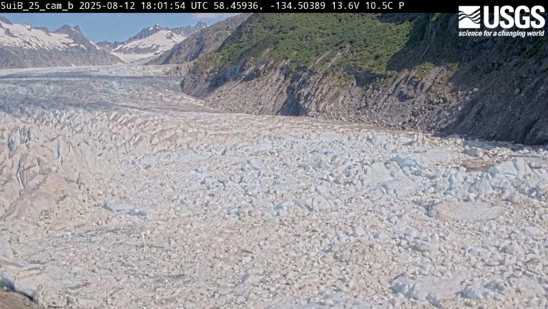
A view shows the Suicide Basin on Aug. 12, 2025, during glacial lake outburst flooding from the Mendenhall Glacier in Juneau, Alaska, in this screengrab from a timelapse video released by the United States Geological Survey (USGS). USGS/Handout via Reuters
Later Wednesday morning, U.S. Forest Service ranger Michael Downs told reporters at a news conference that the west side of the glacier's recreation area remained underwater, along with a number of trails in the national forest that surrounds it. The Forest Service has closed the entire Mendenhall Glacier Recreation Area until further notice, and Downs said at the briefing that it will likely be five or six days before rangers are able to fully assess the situation. The visitor's center in the recreation area, however, will reopen on Thursday, he said.
Public schools in Juneau will delay their return for the upcoming academic year by one day, resuming classes on Friday instead of Thursday, said Frank Hauser, the school district superintendent.
Flooding from the basin has become an annual concern since 2011, and in recent years has swept away houses and swamped hundreds of homes. Government agencies installed temporary barriers this year in the hope of protecting several hundred homes in the inundation area from widespread damage.
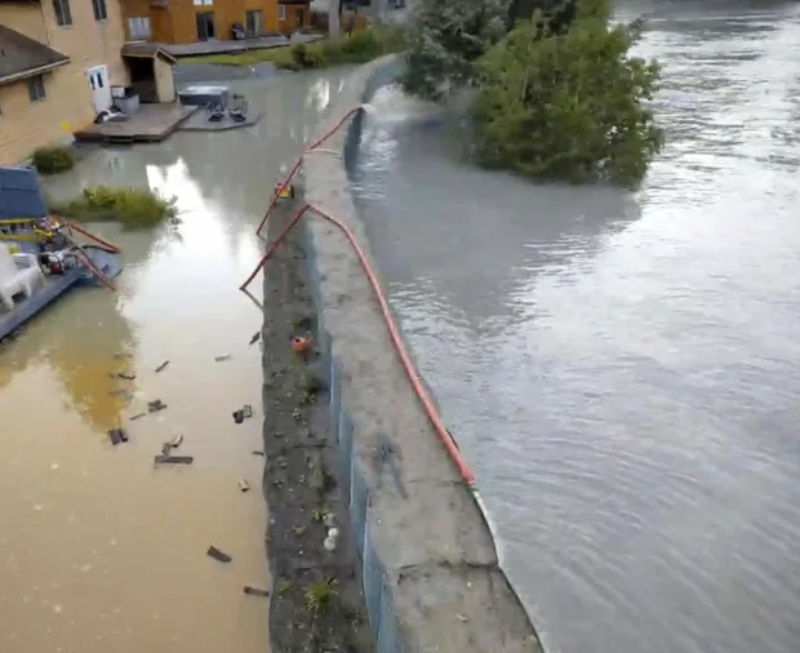
This drone image provided by the City and Borough of Juneau shows flooding from a release of water and snowmelt at Mendenhall Glacier covered some roads and threatened homes along the Mendenhall River in Juneau, Alaska on Wednesday, Aug. 13, 2025. City and Borough of Juneau via AP
The flooding happens because a smaller glacier near Mendenhall Glacier retreated — a casualty of the warming climate — and left a basin, known as Suicide Basin, that fills with rainwater and snowmelt each spring and summer. When the water creates enough pressure, it forces its way under or around the ice dam created by the Mendenhall Glacier, enters Mendenhall Lake and eventually flows down the Mendenhall River, as it did Tuesday.
Before the basin began overtopping, the water level was rising rapidly — as much as 4 feet per day, according to the National Weather Service.
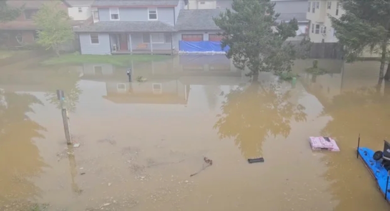
This image provided by Samuel E. Hatch shows flooding from a release of water and snowmelt at Mendenhall Glacier on Wednesday, Aug. 13, 2025 in Juneau, Alaska. Samuel E. Hatch via AP
The city saw successive years of record flooding in 2023 and 2024 — with the river last August cresting at 15.99 feet, about a foot over the prior record set a year earlier — and flooding extending farther into the Mendenhall Valley. This year's flooding was predicted to crest at between 16.3 and 16.8 feet, the weather service said, but then said an even higher 16.75 feet was more likely.
Last year, nearly 300 residences were damaged.
Video posted on social media two years ago showed towering trees behind a home falling into the rushing Mendenhall River as the water ate away at the bank. Eventually, the home, teetering at the edge, also collapsed into the river.
A large outburst can release some 15 billion gallons of water, according to the University of Alaska Southeast and Alaska Climate Adaptation Science Center. That's the equivalent of nearly 23,000 Olympic-size swimming pools. During last year's flood, the flow rate in the rushing Mendenhall River was about half that of Niagara Falls, the researchers say.
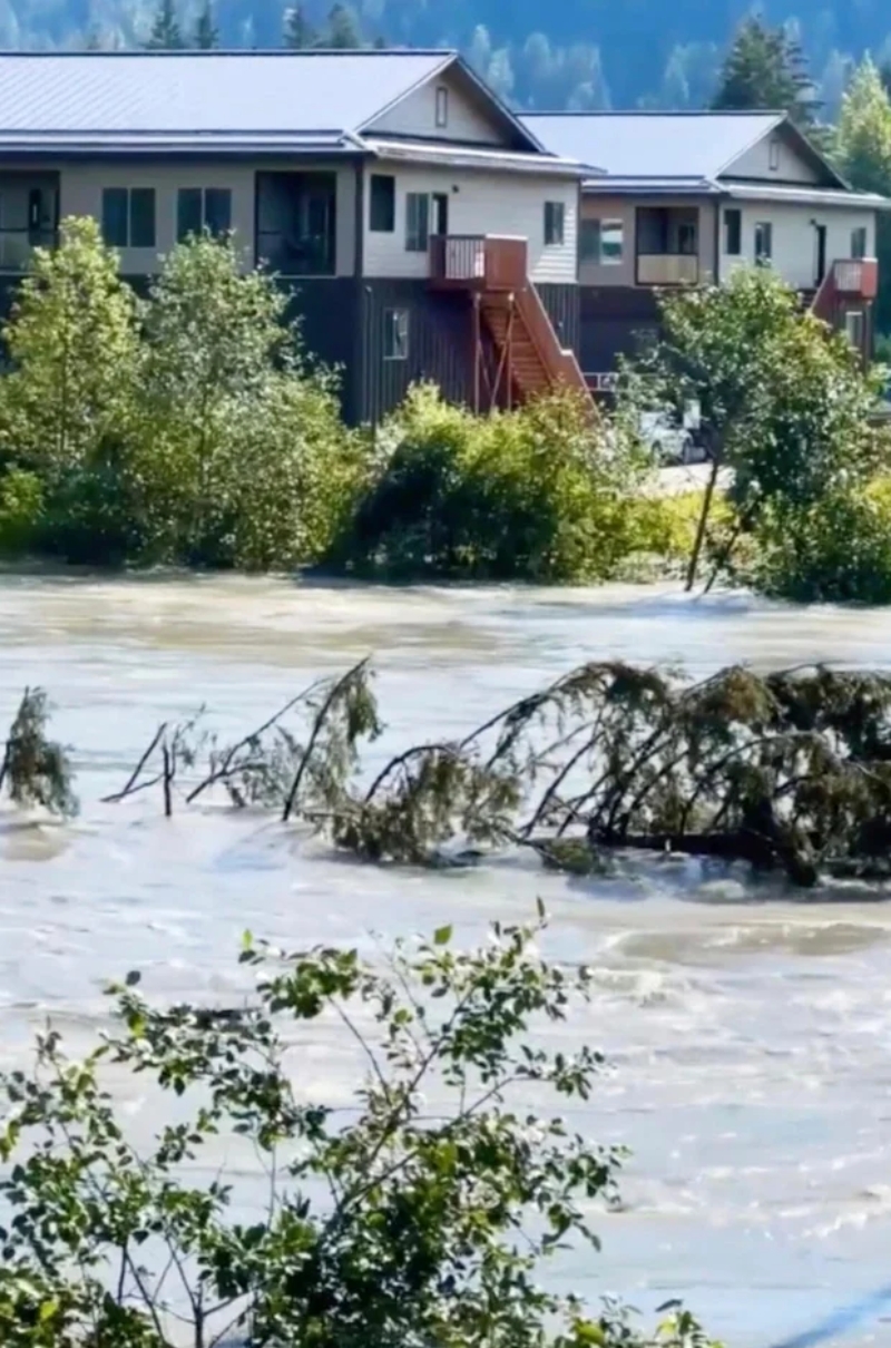
This image taken from a video provided by Wayne Cragg shows the engorged Mendenhall River flowing through Juneau, Alaska, on Wednesday, Aug. 13, 2025. Wayne Cragg via AP
City officials responded to concerns from property owners this year by working with state, federal and tribal entities to install a temporary levee along roughly 2.5 miles of riverbank in an attempt to guard against widespread flooding. The 10,000 "Hesco" barriers are essentially giant sandbags intended to protect more than 460 properties completely during an 18-foot flood event, said emergency manager Ryan O'Shaughnessy.
The U.S. Army Corps of Engineers is at the start of what's expected to be a yearslong process of studying conditions in the region and examining options for a more permanent solution, such as a levee. The timeline has angered some residents, who say it's unreasonable.
Outburst floods are expected to continue as long as the Mendenhall Glacier acts as an ice dam to seal off the basin, which could span another 25 to 60 years, according to the university and science center researchers.
